Notes on the poem "The Kalka Mail"
Viewing of Images
Note: The instructions directly below are for the "web-view" setting on a web-browser. So they might not work when this page is viewed in a cell-phone in the "mobile-view" mode.By clicking on any image below, you can see a somewhat larger and clearer version of that image, against a black background. By clicking on the thumbnail images that then appear on the bottom of the screen (or by using the left and right arrow keys on your keyboard) you can page through the other images on this post, in that same larger and clearer view.
Captions, however, will not be visible in that "gallery view".
To return to this post, please click on the large white "X" at the right top corner of the black background in the gallery view.
If the images and captions below are too small to be read with ease, please use the "zoom" enlargement/reduction feature now available on most web-browsers.
If that does not suffice, to view just the larger, clearer versions of the images (especially the maps), without the captions, please use the "gallery view" described above.
Contents
A) Place Names and other Vocabulary (in order of occurrence in the poem), with Pictures and Maps
B) Some Cities, States/Provinces and Regions of the Subcontinent (mentioned in the poem or its preface)
C) Geography of the Subcontinent and the Violent Creations of Three of its Modern Nation-States
 |
| Political map showing Afghanistan and the Indian subcontinent, with its six nation-states http://www.pakinside.com/wp-content/uploads/2014/12/indian-subcontinent-map.jpg |
A) Place Names and other Vocabulary (in order of occurrence in the poem), with Pictures and Maps
A1) Kalka: See B1 below.A2) ikka or ekka: an Urdu/Hindi term for a two-wheeled carriage drawn by one horse, with seats for the driver and a couple of passengers. The tanga/tonga is a larger version, with more seats, at times covered. The bagghi (buggy) is an yet larger, four-wheeled carriage. These traditional horse-drawn passenger vehicles of the northern subcontinent have been disappearing from the cities. See: http://www.thehindu.com/news/cities/Delhi/the-ikka-walahs-fade-into-history/article6359579.ece and https://lucknow.me/know-your-city-ikka-tanga-aur-lucknow/ .


 | ||
| Rickshaw, with puller and passenger, Bengal ? http://humangoods.net/wp-content/uploads/2009/06/human-horsepower.jpg |
 |
| Rickshaws in Rain http://defence.pk/threads/cycle-human-rickshaw-a-cruelty-pictures-only.409679/ |
 |
| Calcutta rickshaw http://defence.pk/threads/cycle-human-rickshaw-a-cruelty-pictures-only.409679/ |
 |
| Hand pulled rickshaw in Kolkata's waterlogged streets http://defence.pk/threads/cycle-human-rickshaw-a-cruelty-pictures-only.409679/ |
| Sheikh Abdullah of Kashmir and Jawaharlal Nehru, walking (on left), with Sardar Vallabh Bhai Patel. in rickshaw, Shimla (Simla), 1940's http://defence.pk/threads/cycle-human-rickshaw-a-cruelty-pictures-only.409679 |
 |
| Two young women on a cycle rickshaw http://www.loupiote.com/photos_l/11315211203-two-young-women-cycle-rickshaw-india.jpg |
------------------------------------------------------------------------
The Plight of Rickshaw Pullers in Kolkata -- a Video
https://youtu.be/XEeTmWA1ALI
------------------------------------------------------------------------
A4a) T'aligo`nj (Tallygunge) and Bou Bajar (Bau Bazaar): localities in the city of Kolkata (Calcutta), regarding which see B6 below.
A4b) Asansol: the second largest city (after Kolkata) in the state of West Bengal, in Bardhaman (Burdwan) district. Asansol lies on the state's western border, near to the state of Jharkhand. On trains headed northwest to Dilli (Delhi) from Kolkata, this is the last major stop in West Bengal. It will be better described and illustrated when this page is updated.
A5) “Ça, gawrom ça!” ("Cha, gawrom cha!"): "Tea, hot tea!" a commonly heard cry, in Bangla (the Bengali language) in railway stations. Tea vendors used to run along the platform dispensing hot, milky tea from kettles into disposable, baked-clay cups. Similar cries were used by tea-vendors speaking related Eastern Indian languages and dialects
 |
| Vendor pouring tea for a passenger in a train at a railway platform in India https://www.pinterest.com/pin/217861700698786749/ |
 |
| Disposable baked clay tea cups, Kolkata (Calcutta), West Bengal http://chaiwallahsofindia.com/wp-content/uploads/2015/02/clay-cups-kolkata.jpg |
A6) Bengal: a fertile, riverine, densely populated region in the eastern part of the subcontinent. It consists mainly of the combined delta of the Ganga (Ganges) and Brahmaputra rivers. The main languages are Bengali and its dialects--although many other languages are also spoken. Islam and Hinduism are the major religions, although several other religions are also extant. Bengal was once an undivided cultural and political entity, However, it was divided, in 1947, on religious grounds, into what is still the Indian state of West Bengal and what first became (1947-1970) East Pakistan and then (from 1970 onward) the country of Bangladesh. Please see B4 below.
A7) “Çae, çae—garam çae!” ("Chaey, chaey--garam chaey!"): "Tea, tea--hot tea!" in Hindi/Urdu and related Northern Indian languages and dialects. The contents, methods of preparation and flavors of the milky teas prevalent in different parts of the subcontinent vary from region to region.
 |
| Tea in a kulhar https://upload.wikimedia.org/wikipedia/commons/4/4b/Tea-in-a-kulhar.JPG |
 |
| South Indian coffee, frothed and served in a typical metal cup and bowl http://a.ctimg.net/OKEILkwdRl2cJdEFqKkxfQ/recipe-to-make-filter-kaapi-how-to.1024x1024.jpg |
 |
| South Indian coffee being cooled and aerated (frothed) https://i.ytimg.com/vi/dBEhlU_lFjo/hqdefault.jpg |
 |
| South Indian coffee being cooled and aerated http://cf1.netmegs.com/memestream/coffee%201.JPG http://www.chowandchatter.com/2009/07/south-indian-filter-coffee.html |
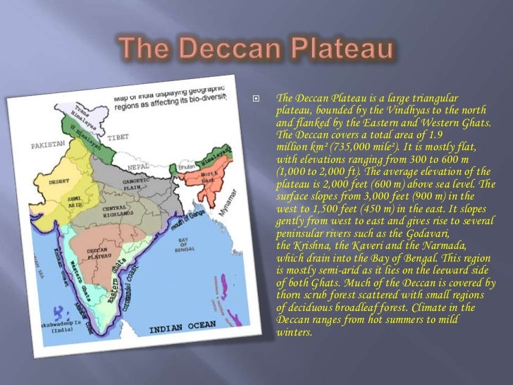
A9) Deccan: southern. This Anglo-Indian word is from the Sanskrit dakxin (dakshin), meaning "right-hand". This is the direction towards south when one is facing east, which is purva (in front) while the west is paxçim (pashchim, behind). The Deccan plateau occupies the interior part of peninsular India, which was once attached to what is now eastern Africa. The Tethys Sea that once arced between what is now peninsular India and the rest of Asia further north was filled up, over the eons, by sediments carried down from the Himalayas that were raised up (along with the Tibetan plateau and more) as the Indian-Australian plate wedged under the Eurasian plate. These deposits now constitute the low-lying, fertile arc of the Indo-Gangetic plains.
 |
| The Deccan Plateau, in relation to other physiographic divisions of India http://image.slidesharecdn.com/physiographicdivisionsofindia-120129072407-phpapp01/95/physiographic-divisions-of-india-18-728.jpg |
 |
| Plateau regions of peninsular India source: unknown |
A10) Çhot’a Nagpur (Chhota Nagpur): a hilly region, in the east-central part of the subcontinent, with the hills being being the eroded remains of a northeastern intrusion of the southern plateaus. It lies between the rest of peninsular India to its south and west, the upper plains of the Ganges to its north and west, and the Bengal delta to its east. From the trains running between Kolkata (Calcutta) and Dilli (Delhi) in the 1950's, the crossing through this hilly region between the delta and the northern plains was magical, with the tall, dreaming Chhota Nagpur hills, which were then still densely wooded, appearing blue-green from a distance.
 | |
Chhota Nagpur Ecoregion
|
 |
| Low outlying hills of Chhota Nagpur in Bankura district, W. Bengal http://easternheavens.com/userfiles/clix_easternheavens/images/south_bengal05.jpg |
The Mughals were an imperial dynasty in India, whose first emperor, Babar, became marooned in north India during a looting raid, when his ancestral seat, in the Ferghana valley of what is now Afghanistan, was taken by a rival warlord. Babar was descended, on his father's side, from Islamicized and Persianized Turkic tribesmen, with Timurlang (Tamerlane) as a paternal ancestor. On his mother's side, he was of Mongol descent, with Genghis Khan as a maternal ancestor. So Babar was able to command, as his raiding army, a diverse crew of Central Asian and Afghan tribes, who collectively came to be known in India as "mughals" or "moghuls".
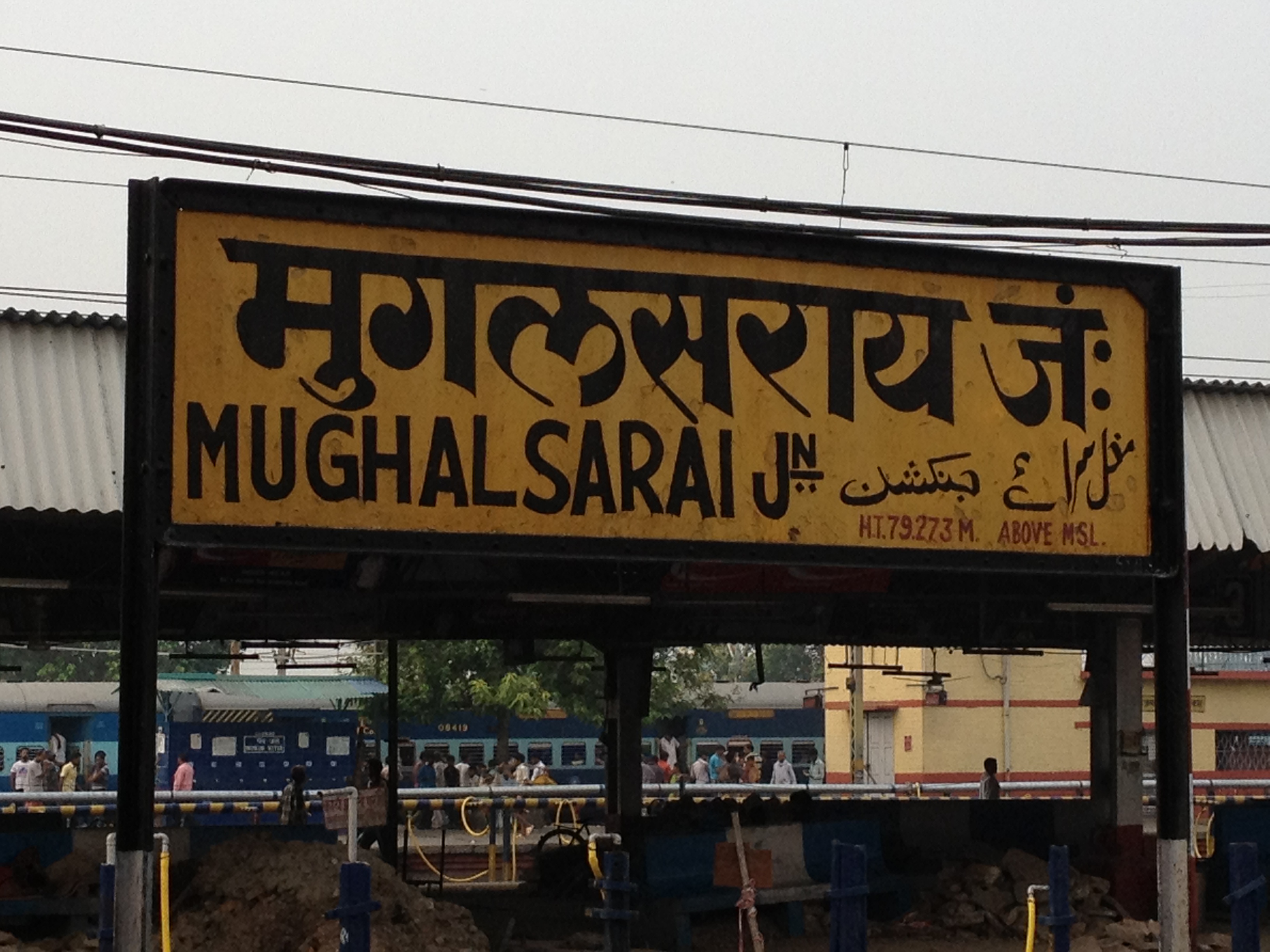
Mughal Sarai has been an important railway junction in North India since British times, lying about halfway between Kolkata and Dilli (Delhi), in what is now the north Indian state of Uttar Pradesh (Northern Province). It lies close to the city of Varanasi (Benares/Banaras/Kashi) on the Ganges, the ancient holy city of the Hindus. Mughal Sarai lies on the way to Varanasi from Gaya, a city to its east, in Bihar, near to Bodhgaya, a site revered by Buddhists as being the place where the Buddha was enlightened.
When we note the location between Varanasi and Gaya, and note further that this railroad junction at Mughal Sarai came into existence during British rule, while the much older name of the place, with its Mongol, Turkic and Farsi roots, derives from northern and central Asia, we begin to get a sense of some of the cultural interactions that occurred in this region.
 |
| Sign at the Mughal Sarai Railroad Junction, in Hindi, English and Urdu http://photos.wikimapia.org/p/00/04/06/39/51_full.jpg |
 |
| Tomb of Humayun, the second Mughal emperor, son of Babar, in what is now a suburb of New Delhi, near to the gravesite of the saint Nizamuddin, and close to a library devoted to the Urdu poet Ghalib. When I was a young teenager, my family moved from Kolkata to New Delhi, and we lived next to this site. I spent many hours, after school and on weekends, on the greens, where our two dogs could run free. Humayun might not have liked this, as dogs, like pigs, are considered to be haraam in Islam. https://travelblog.expedia.co.in/wp-content/uploads/2015/12/New-delhi-Humayuns-Tomb-feature.jpg |
 |
| Purana Qila (Old Fort), New Delhi. These fortifications were renovated by Humayun, 1533-1538, and soon after by an Afghan king, Sher Shah Suri, who defeated Humayun. But the site dates back several thousand years, as has been revealed by excavations, and might even be the Indraprastha of the Pandava clan, heroes of the ancient Hindu Arya epic, the Mahabharata. https://upload.wikimedia.org/wikipedia/commons/b/b5/Purana_Qila_ramparts,_Delhi.jpg |
A14) Dhaka: formerly Dacca, the capital of East Pakistan and later Bangladesh.
A15) Howrah: a city immediately across the wide Hooghly river from Kolkata (Calcutta), The main local railway station is located there.
A16) Medinipur: Midnapore, the southwestern-most district of West Bengal, bordering the state of Od'isha (Orissa). It is a coastal district on the Bay of Bengal. My father's father came from that district. The city of Tamluk (ancient Tamralipta) was an old sea-port from which locals once voyaged across the Bay of Bengal and the Indian Ocean to places as far as what is now Malaysia, Indonesia and Indochina,
A17) Çat'ga~: Chittagong, the southeastern-most district of East Bengal (later East Pakistan and then Bangladesh). Chittagong district borders the Arakan region of Myanmar (Burma), contains hilly tribal regions in its interior and the important port city of Chittagong on its coast. It lies across the Bay of Bengal from Medinipur and Od'isha,
A18) 'Pind'i, Quetta and Peshawar: 'Pind'i (Rawalpindi), is a city in what became West Pakistan. It is situated at the start of the foothills of the Himalayas, close to the modern capital of Islamabad. The Pakistani capital has moved over time from the port city of Karachi to Rawalpindi to Islamabad. Quetta is a city in Baluchistan, in the west of Pakistan, bordering Iran and Afghanistan. Peshawar is a city in what is now Khyber-Pakhtunkhwa (formerly the North West Frontier Province) in the north of Pakistan, bordering Afghanistan.
A19) phat'phat'i: phatphatiya, an eight passenger vehicle, consisting of an elevated, covered cart attached to a powerful motorcycle. This was once a popular means of transport in Dilli, being a larger cousin of the scooter rickshaw and much noisier. The loud, puttering sound of its engine led to its onomatopoeic name.
 |
Two three-wheeled vehicles: a scooter rickshaw (left), driven by a turbaned Sikh man,
and a phatphatiya (right) carrying two women passengers on the covered cart, driven
by a man seated on the attached motorbike. Connaught Place, New Delhi.
|
========================================
B) Some Cities, States/Provinces and Regions of the Subcontinent (mentioned in the poem or its preface)
|
| Political map showing Afghanistan and the Indian subcontinent, with its six nation-states http://www.pakinside.com/wp-content/uploads/2014/12/indian-subcontinent-map.jpg |
B2) Kashmir: a former independent "princely state", ruled by a Maharajah, during the British Raj. It is located in a mountainous region in the northernmost part of the subcontinent, . After the partition of the subcontinent in 1947, most Kashmiris sought to remain independent, but instead the region was (and still is) claimed and carved up between what became the Republic of India and what became the Islamic Republic of Pakistan. The Indian region is now the state of Jammu and Kashmir, and the Pakistani region is the province of Azad Kashmir.
 |
| Political map of the subcontinent, showing the states of the Republic of India, as of 2015, along with adjoining countries (Warning: ultranationalist site!) https://themuslimissue.files.wordpress.com/2015/05/india_map-and-borders-in-2015.jpg |
After several decades, the influx of Wahabi Sunni theology and militancy in the late 1980's, 1990's and early 2000's resulted in an ethnic turn to the conflict. So most of the minority Hindu Pand'its (Brahmins), who had generally lived peaceably among the mostly Muslim population of the Valley of Kashmir through the ages, were forced to leave.
In the 1960's. Ladakh, a region in the NE, part of the Tibetan plateau, inhabited by followers of Tibetan Buddhism, was claimed and occupied by China. This resulted in a high-altitude war with India in which China prevailed.
The Indian portion includes the valley of Kashmir, where the main language is Kashmiri, and the region of Jammu in the south, where the main language is Dogri, and which was and remains mostly Hindu. The Pakistani portion in the north and west includes mountainous regions inhabited by various Muslim tribes speaking a number of languages.
Urdu and its sibling, Hindi, are widely understood in Kashmir.
In addition to clashes between the military and insurgents and the population itself, there have been several wars between India and Pakistan that began in or involved Kashmir.
B3) Çennai (Chennai, formerly Madras city): a beautiful city on the east coast of South India, capital of the state of Tamilnad'u (Tamilnadu, formerly Madras state). The original name might be connected with madrasa (an Arabic word for a religious school, cognate to the Hebrew midrash). Madras city was once the center of the large Madras Presidency of the British Raj. The division of the Republic of India into states based mainly on language occurred some time after Independence and has been ongoing since. English is widely understood in Chennai city, but the main language there and in the rest of Tamilnadu is Tamizh (Tamil), a Dravidian language closely related to Malayalam to the west and, more distantly, to Telengu (Telegu) to the north and to Kannad'a (Kannada) and Tulu to the northwest. Tamil (along with Malayalam) is also spoken in parts of Sri Lanka (Ceylon).
 |
| Political map of Afghanistan, Myanmar (Burma) and the subcontinent, showing capitals and major cities. Kolkata is in the east, near Bangladesh. Delhi is the north center. http://www.mapsofindia.com/neighbouring-countries-maps/indian-subcontinent-map.html |
B4) Bengal: a mainly low-lying, wet and fertile delta region in the eastern part of the subcontinent. Bengal was divided on religious grounds, during the partition of 1947, into what became the Indian state of West Bengal and what became East Pakistan. This was accompanied by massacres and movements of millions of refugees across borders, in a great (partial) ethnic cleansing. The Hindu-Muslim riots that started in Kolkata (Calcutta) spread throughout Bengal and also soon reached other parts of the subcontinent--particularly the Punjab (the land of the five rivers, in Farsi), which had also been divided on religious grounds. There, there were even greater massacres, and an almost complete ethnic cleansing of the region, with Muslims fleeing west across the new border, and Hindus and Sikhs fleeing east.
In 1970, following an election in Pakistan won by a party based mainly in East Pakistan, and a subsequent fierce military clampdown there (that again sent about a million terrified refugees, mostly Hindus, but also Muslims, especially students, into West Bengal and other adjoining parts of India), an intervention by the Indian army led to the creation of what later became the Islamic Republic of Bangladesh.
The main languages spoken in Bengal, on both sides of the border, are dialects of Bengali, with the standard written and spoken language, along with a literary tradition, taught in the schools and used for formal communication on both sides.
West Bengal has had a long history of leftist coalition governments, including two major Communist parties and other socialist parties.
|
| Political map of the subcontinent, showing the states of the Republic of India, as of 2015, along with adjoining countries (Warning: ultranationalist site!) https://themuslimissue.files.wordpress.com/2015/05/india_map-and-borders-in-2015.jpg |
B6) Kolkata (Calcutta): currently the teeming, bustling capital of West Bengal state, being a port city situated mainly on the eastern banks of the Hooghly river (an estuary of the Ganges). Kolkata is an ethnically diverse city, with a significant cultural history dating from the Bengal Renaissance that began with the meeting of western and native cultures initiated by the British rule that spread out from Bengal, with Calcutta long being the regional imperial capital during the British Raj. Calcutta has also had its share of extreme misery and poverty (dating from the time of the predatory British East India Company), of refugee influxes dating from the partition of 1947, and of political unrest.
|
| Political map of Afghanistan, Myanmar (Burma) and the subcontinent, showing capitals and major cities. Kolkata is in the east, near Bangladesh. Delhi is in the north center. http://www.mapsofindia.com/neighbouring-countries-maps/indian-subcontinent-map.html |
B7) Dilli (Delhi): the old center of power of the Mughal and other Indian empires, with New Delhi being the capital for undivided India in the latter part of rule by the British Raj, and continuing till now as the capital of the Republic of India, being located in the Union Territory of Delhi, adjoining the states of Uttar Pradesh to its east and Haryana (once part of the Punjab) to its west.
========================================
C) Geography of the Subcontinent and the Violent Creations of Three of its Modern Nation-States
While Kolkata (Calcutta) lies in the Bengal delta in eastern India, Dilli (Delhi) sits nine hundred miles to the northwest, at the slightly raised divide marked by the old, worn Aravalli hills. This is where the plains of the Ganga (Ganges) and Jamna (Yamuna), sloping to the southeast, meet those of the Sindhu (Indus) and its tributaries, sloping to the southwest. |
| The subcontinent, with low-lying plains and coastal areas in greens, higher areas in yellows and browns. https://s-media-cacheak0.pinimg.com/736x/95/d5/d8/95d5d84a18cb7fc60ba99323cf38bc23.jpg |
 |
| Map of the rivers of the subcontinent: The Himalayan arc separates China (Tibet) from the subcontinent. The major rivers of North India arise on the Tibetan side of the Himalayas. The plains of the Indus are in the NW, those of the Ganges, just south of the Himalayan arc, lead to the Bengal delta in the east. The Assam valley of the Brahmaputra (Tibetan Tsangpo) is in the NE. The southern plateau of peninsular India slopes, generally, from the west to the east. Most of the major rivers of the peninsula follow that slope, with several starting in the Western Ghat mountains near the west coast of the peninsula, and flowing east from there to the Bay of Bengal. Some, however, further north, flow west into the Arabian Sea. http://www.mapsofindia.com/maps/india/india-rivers-map.jpg |
The large island of Sri Lanka (Ceylon) is visible. So is the chain of the much smaller Andaman and Nicobar islands, in the SE. The international borders are marked (not too visibly in darker areas) in black and brown. The major rivers are in black.
The trains to Dilli from Kolkata’s Howrah station travel northwest from the delta, up the Gangetic plain. Some of the routes encounter, when leaving the delta, an intrusion of the Deccan (dakxin = dakshin) = southern) peninsula. These are the hills of the Çhot’a Nagpur (Chhota Nagpur) plateau. In the 1950’s, when I first rode a train from Kolkata to Dilli, those hills were still well forested.
Howrah lies across the Hooghly river from Kolkata, From that starting point in the southeast of India, the westbound Kalka Mail ran all the way to the town of Kalka in the northwest. That town lies in what was once the eastern part of the undivided Punjab. In 1947, after the partition of the subcontinent and the end of British rule, this eastern Punjab became part of independent India, with the western Punjab becoming part of West Pakistan. Later, in 1966, after the Indian Punjab was further subdivided, the town of Kalka became part of the Indian state of Haryana.
|
| Political map of the subcontinent, showing the states of the Republic of India, as of 2015, along with adjoining countries (Warning: ultranationalist site!) https://themuslimissue.files.wordpress.com/2015/05/india_map-and-borders-in-2015.jpg |
After the partition of 1947, train and other routes that used to run between what became, eventually, the Republic of India and the Islamic Republic of Pakistan (with its eastern and western wings) had been suddenly interrupted. In particular, trains had ceased to run between the Indian capital in New Delhi and the Pakistani capital, which moved over time from Karachi to Rawalpind'i to Islamabad—all in West Pakistan.
Punjab, in the northwest of the subcontinent, was one of two British provinces that were cut in two by the partition of 1947. In the east, the province of Bengal was also split. The western part of Bengal became the Indian state of West Bengal and the eastern part became East Pakistan.
So the land routes between the two parts of Bengal had also been interrupted, along with the sea routes between the old Bengal’s westernmost district, Medinipur (Midnapore), and its easternmost one, Ç~at’ga~ (Chittagong). These two districts lay on opposite sides of the Bay of Bengal.
Much later, in 1970, East Pakistan became Bangladesh.
The partition of 1947 had been accompanied by tremendous human misery, as refugees who happened to be of the "wrong religion" fled across the new borders that divided the Punjab in the west and Bengal in the east. Countless numbers had been slaughtered in massacres.
The events leading to the birth of Bangladesh in 1970 were also marked by horrors in East Pakistan—beginning with a fierce military clampdown that negated the results of an election—and yet another flight of terrified refugees across a border.
I cannot go here into the history of the railroads in the subcontinent, that began in the British Raj. Suffice it to note that those railroads, running thousands of miles, were built, as elsewhere, mainly by human (and animal) labor.
– Babui (Arjun) 2016 May 1, Sun. (edited and expanded June 6th, Sun.)
-----------------------------------------------------
Return to the post "The Kalka Mail".
1 comment:
thanks for sharing such a great post.
great and awesome post.
Post a Comment